
Living Shoreline
The Franklin-98 Living Shoreline project is restoring resilience along one of Florida’s most vulnerable coastal highways and hurricane evacuation routes
By Will Mather, Environmental Scientist, WSP in the U.S.
The project is rebuilding coastal habitat, while also safeguarding infrastructure in Franklin County.
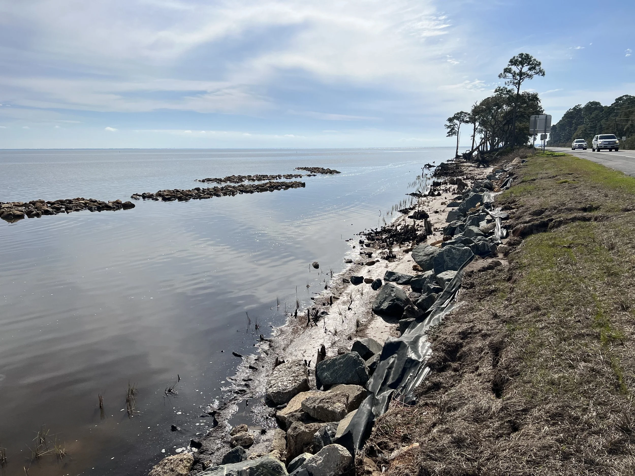
When you drive between Eastpoint and Carrabelle in Florida, you quickly realize how close that stretch of U.S. Highway 98 (US-98) is to the open water of Apalachicola Bay.
In fact, much of the asphalt shoulder falls directly into the bay, leaving just a slim strip of land between commuters and water.
This isn’t just a dire concern for the residents who use this route daily; it’s also a plight for entire communities who depend on this route as a hurricane evacuation corridor. Those fears were realized when Hurricane Michael devastated the region in 2018. Sections of this corridor were washed out and access was cut off for families and emergency responders.
That’s why the Franklin-98 Living Shoreline project is so vital, as we use nature-based solutions to reshape miles of coastline. This is a multi-phase effort that pairs low-profile oyster reefs with restored salt marsh to stabilize the shoreline, reduce wave energy and rebuild the bay’s coastal ecosystems.
Designed and implemented in partnership with the Apalachee Regional Planning Council (ARPC) and supported by grants from the National Fish and Wildlife Foundation (NFWF), the project stands as a regional model for resilient, community-focused coastal protection.
Safeguarding against erosion
This 12-mile corridor of US-98 suffers from chronic near-shore erosion, and its steady encroachment on the highway threatens habitats, infrastructure and local access for residents.
Prior vulnerability studies like the Shoreline Habitats and Resilient Coasts project identified this area as one of the most vulnerable sections to erosion of the entire bay. Sea-level rise, vessel wakes, storm surge pathways and shoreline geometry are converging to create an environment in which traditional solutions like riprap — naturally engineered seawalls — only grant limited, temporary relief.
This highway is a lifeline for the locals, and the threat is imminent. That’s why the goal for this project was not to simply mitigate the erosion, but instead enhance and rebuild the ecological foundation that naturally safeguards the coast.
Low‑profile reef structures and restored marsh are reducing wave energy on Apalachicola Bay’s shoreline.
Low-profile problem solving
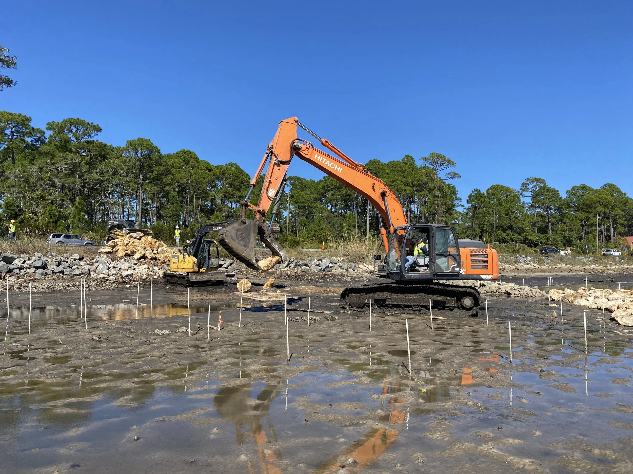
Franklin-98 spans the shoreline of this 12-mile corridor, with approximately 6 of those miles selected for installation based on environmental suitability, land-use constraints and hydrodynamic modeling.
The first phase was completed in spring 2024, creating approximately 5,500 linear feet of reefs and initial marsh plantings. The second and third phases, which are scheduled for completion by the end of 2026, will add roughly 6,500 linear feet of reefs and more than 500,000 marsh plantings.
The project’s two core components — salt marsh reconstruction and oyster reef structures — work together as a living, protective ecosystem.
The goal is to create 30 acres of restored marsh planted with native species, which helps stabilize sediment and expand near-shore habitat in the area.
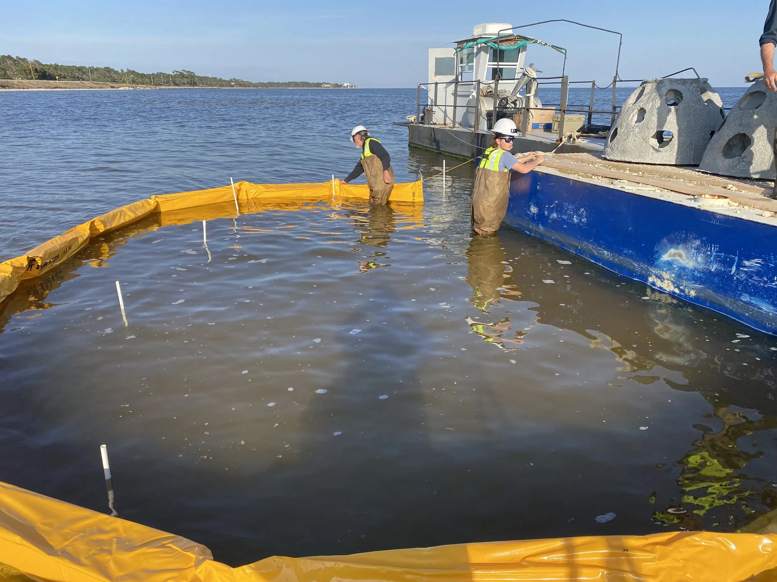
That’s in addition to a goal of approximately 20 acres of estuarine reef that’s being installed using limestone and precast concrete modules. These low-profile structures reduce wave energy, trap sediment and provide substrate for natural oyster recruitment.
We specifically designed a low-profile, visually appealing reef with a deliberately organic footprint that still maximizes the number of oysters that can recruit to the structure.
In other words, we wanted these structures to fit the environment — not the other way around.
From science to buildable solutions
The Franklin‑98 Living Shoreline project is helping to stabilize the coast along US-95 and protect a vital evacuation route.
WSP’s role on this project began in 2019, when our team undertook a multi-year program of baseline monitoring, site characterization, engineering design and geotechnical analysis.
The scope of our work has included:
mapping bathymetry, seagrass distribution and sediment composition;
surveying marsh and oyster habitat to identify ecological elevation windows;
modeling sediment transport and wave attenuation performance;
designing reefs so that crest elevations match naturally occurring oyster growth levels;
determining planting elevations for marsh vegetation; and
conducting geotechnical assessments to confirm that reef weight would not trigger long-term subsidence.
The first phase of construction was successfully completed by North Florida Construction, who installed limestone boulders and reef modules. All of this required careful coordination, whether it was brief closures of US-98 to safely move rocks to the water’s edge, or consideration of the tides, shifting sandbars, and weather conditions that impacted the schedule daily.
Permitting puzzle
Even more complex than the project’s engineering was its permitting. Multiple state and federal agencies required approvals, such as the U.S. Army Corp of Engineers, Florida Department of Environmental Protection (FDEP) and Florida Fish and Wildlife Conservation Commission.
Perhaps our biggest challenge was collaboration with more than 20 private landowners, all with their own parcels of land in this corridor. The State of Florida owns the submerged lands within this corridor, but riparian rights give upland owners a say in what is built offshore near their property.
The original approach was to reach out to all landowners and have them cosign a single master permit authorization, but that didn’t work because many owners do not know each other, live elsewhere seasonally or rely on separate legal counsel.
So WSP instead partnered with FDEP to refine the approach to first conduct a “mean high-water line”survey to document property boundaries, linking individualized boundary line agreements to the “mean high-water line” survey and subsequently split the private landowner signatures into parcel-specific authorizations, which allowed each owner to sign independently.
It was a bear to figure out, but it was necessary to protect everyone’s rights and keep the project moving forward. Plus, the lessons that we learned from phase two permitting are now being applied to phase three, which includes 12 additional, private landowners.
Partners in community
This project was shaped by its complexities and challenges, but it was crucial partnerships that allowed the project to begin in the first place. Those key partners include:
Apalachee Regional Planning Council – Project owner
Apalachicola National Estuarine Research Reserve – Critical technical partner and permit owner
Harter Restoration & Consulting, LLC – Collaborator on permitting, stakeholder coordination, and project design
Franklin’s Promise – Led phase one marsh planting and assisted with reef construction
North Florida Construction – Construction contractor
Supported by local construction contractors Coastline Clearing and Jason White Construction
National Fish and Wildlife Foundation – Primary funder across multiple grants
Community engagement helped inform major decisions throughout this project. Working alongside ARPC, our team met residents where they were — at Eastpoint Civic Association meetings, local fairs, seafood festivals, restaurants and fishing spots. Public input has been key to project success to date.
We had a large, printed map on which residents could mark areas of concern, and as they watched phase one reefs begin to accumulate sediment and protect their shorelines, we saw public support grow.
Visions of success
The Franklin-98 Living Shoreline project represents a bold step forward for coastal resilience, and the project’s annual monitoring program — which tracks seagrass, oysters, marsh density and shoreline change — shows early, promising signs.
Per our 2025 Annual Report, marsh density and height at the project sites are “comparable to or exceeding” reference marshes, and both oyster recruitment and sediment accretion is active, with the latter expanding the habitat.
Over the next two years, we expect fully vegetated marsh expansions, reef structures naturalized into self-sustaining oyster habitats and continued sediment accretion and shoreline stabilization.
But for me, personally, I have another vision for this project in the coming years: people driving by, seeing our work and not realizing it’s all man-made.
I want them to look out their windows and say, “Oh wow, that’s an oyster reef,” and then keep on driving.